Assessing Human Settlement Sprawl in Mexico via Remote Sensing and Deep Learning
Keywords:
settlements sprawl, urban growth, human footprintAbstract
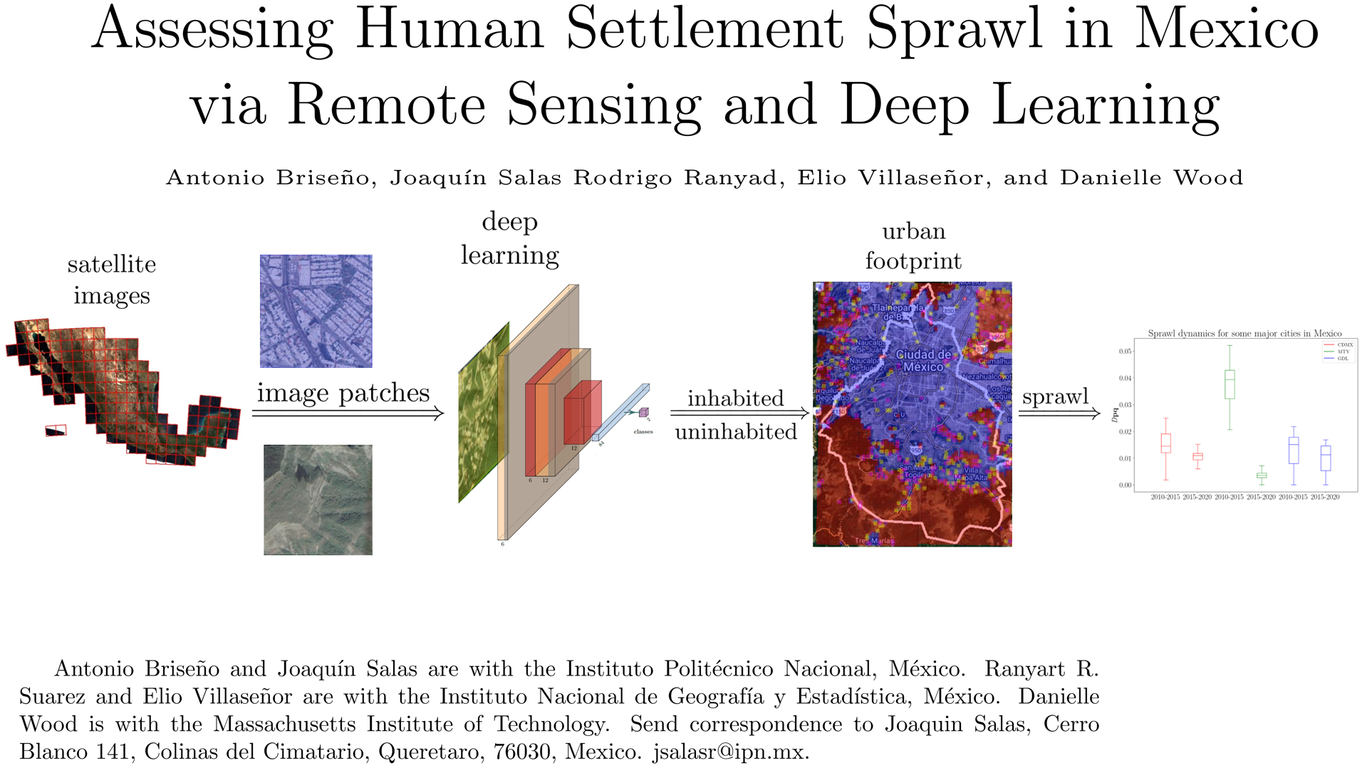
Understanding human settlements' geographic location and extent can support decision-making in resource distribution, urban growth policies, and natural resource protection. This research presents an approach to assess human settlement sprawl using labeled multispectral satellite image patches and Convolutional Neural Networks (CNN). By training deep learning classifiers with a dataset of 5,359,442 records consisting of satellite images and census data from 2010, we evaluate sprawl for settlements across the country. The study focuses on major cities in Mexico, comparing ground truth results for 2015 and 2020. EfficientNet-B7 achieved the best performance with a ROC AUC of 0.970 and a PR AUC of 0.972 among various CNN architectures evaluated. To evaluate human settlement sprawl, we introduce an information-based metric that offers advantages over entropy-based alternatives.
Downloads
References
REFERENCES
UN, “World Population Prospects 2019,” tech. rep., United Nations,
10.1111/rssa.12104.
J. Bongaarts, “Slow Down Population Growth,” Nature, vol. 530,
no. 7591, pp. 409–412, 2016. 10.1038/530409a.
H. Ritchie and M. Roser, “Urbanization,” OWID, 2018.
Y. Bengio, Y. Lecun, and G. Hinton, “Deep learning for AI,” Commun.
ACM, vol. 64, no. 7, pp. 58–65, 2021. 10.1145/3448250.
A. Sharif, H. Azizpour, J. Sullivan, and S. Carlsson, “CNN features
off-the-shelf: an astounding baseline for recognition,” in CVPR,
pp. 806–813, 2014. 10.48550/arXiv.1403.6382.
V. Mnih, K. Kavukcuoglu, D. Silver, A. A. Rusu, J. Veness, M. G.
Bellemare, A. Graves, M. Riedmiller, A. K. Fidjeland, and
G. Ostrovski, “Human-level control through deep reinforcement
learning,” Nature, vol. 518, no. 7540, pp. 529–533, 2015.
1038/nature14236.
D. Patterson, J. Gonzalez, Q. Le, C. Liang, L. Munguia, D. Rothchild,
D. So, M. Texier, and J. Dean, “Carbon emissions and large neural
network training,” arXiv:2104.10350, 2021.
48550/arXiv.2104.10350.
K. Anderson, B. Ryan, W. Sonntag, A. Kavvada, and L. Friedl, “Earth
observation in service of the 2030 Agenda for Sustainable
Development,” Geo-Spat. Inf. Sci., vol. 20, no. 2, pp. 77–96, 2017.
1080/10095020.2017.1333230.
J. Reid, C. Zeng, and D. Wood, “Combining Social, Environmental
and Design Models to Support the Sustainable Development Goals,” in
IEEE Aerosp. Conf., pp. 1–13, IEEE, 2019.
E. C. Stokes and K. C. Seto, “Characterizing urban infrastructural
transitions for the sustainable development goals using multi-temporal
land, population, and nighttime light data,” Remote Sens. Environ.,
vol. 234, p. 111430, 2019.
M. Prakash, S. Ramage, A. Kavvada, and S. Goodman, “Open earth
observations for sustainable urban development,” Remote Sens.,
vol. 12, no. 10, p. 1646, 2020.
A. L. Cowie, B. J. Orr, V. M. C. Sanchez, P. Chasek, N. D. Crossman,
A. Erlewein, G. Louwagie, M. Maron, G. I. Metternicht, S. Minelli,
et al., “Land in balance: The scientific conceptual framework for land
degradation neutrality,” Environ. Sci. Policy, vol. 79, pp. 25–35, 2018.
C. Qiu, M. Schmitt, H. Taubenböck, and X. Zhu, “Mapping Human
Settlements with Multi-seasonal Sentinel-2 Imagery and
Attention-based ResNeXt,” in JURSE, pp. 1–4, IEEE, 2019.
1109/JURSE.2019.8809009.
M. Marconcini, A. Metz, S. Üreyen, D. Palacios, W. Hanke,
F. Bachofer, J. Zeidler, T. Esch, N. Gorelick, and A. Kakarla,
“Outlining where humans live, the World Settlement Footprint 2015,”
Sci. Data, vol. 7, no. 1, pp. 1–14, 2020.
6084/m9.figshare.12424970.
C. Corbane, V. Syrris, F. Sabo, P. Politis, M. Melchiorri, M. Pesaresi,
P. Soille, and T. Kemper, “Convolutional neural networks for global
human settlements mapping from Sentinel-2 satellite imagery,” Neural.
Comput. Appl., vol. 33, no. 12, pp. 6697–6720, 2021.
1007/s00521-020-05449-7.
Z. Pan, J. Xu, Y. Guo, Y. Hu, and G. Wang, “Deep Learning
Segmentation and Classification for Urban Village Using a Worldview
Satellite Image Based on U-Net,” Remote Sens., vol. 12, no. 10, 2020.
3390/rs12101574.
C. Qiu, M. Schmitt, C. Geiß, T. K. Chen, and X. Zhu, “A framework
for large-scale mapping of human settlement extent from Sentinel-2
images via fully CNN,” ISPRS J. Photogramm. Remote Sens.,
vol. 163, pp. 152–170, 2020. 10.1016/j.isprsjprs.2020.01.028.
A. Rudiastuti, N. Farda, and D. Ramdani, “Mapping built-up land and
settlements: a comparison of machine learning algorithms in Google
Earth Engine,” in GSS, vol. 12082, pp. 42–52, SPIE, 2021.
1117/12.2619493.
C. Ayala, R. Sesma, C. Aranda, and M. Galar, “A Deep Learning
Approach to Building Footprint and Road Detection in Satellite
Imagery,” Remote Sens., vol. 13, no. 16, p. 3135, 2021.
3390/rs13163135.
J. Hoek and H. Friedrich, “Satellite-Based Human Settlement Datasets
Inadequately Detect Refugee Settlements,” Remote Sens., vol. 13,
no. 18, p. 3574, 2021. 10.3390/rs13183574.
P. Gong, X. Li, and W. Zhang, “40-Year (1978–2017) human
settlement changes in China reflected by impervious surfaces from
satellite remote sensing,” Sci. Bull., vol. 64, no. 11, pp. 756–763,
10.1016/j.scib.2019.04.024.
I. Tingzon, N. Dejito, R. Flores, R. Guzman, L. Carvajal, K. Erazo,
I. Cala, J. Villaveces, D. Rubio, and R. Ghani, “Mapping New
Informal Settlements using Machine Learning and Time Series Satellite
Images: An Application in the Venezuelan Migration Crisis,” in
ICAIG, pp. 198–203, IEEE, 2020. 10.1109/AI4G50087.2020.9311041.
A. Rapuzzi, C. Nattero, R. Pelich, M. Chini, and P. Campanella,
“CNN-Based Building Footprint Detection from Sentinel-1 SAR
Imagery,” in IGRSS, pp. 1707–1710, IEEE, 2020.
1109/IGARSS39084.2020.9323609.
F. Wu, C. Wang, H. Zhang, J. Li, L. Li, W. Chen, and B. Zhang,
“Built-up area mapping in China from GF-3 SAR imagery based on
the framework of deep learning,” Remote Sens. Environ., vol. 262,
p. 112515, 2021. 10.1016/j.rse.2021.112515.
G. Zitzlsberger, M. Podhorányi, V. Svaton, M. Lazeck ˇ y, and `
J. Martinovic, “Neural Network-Based Urban Change Monitoring with ˇ
Deep-Temporal Multispectral and SAR Remote Sensing Data,” Remote
Sens., vol. 13, no. 15, p. 3000, 2021. 10.3390/rs13153000.
S. Fibæk, C. Keßler, and J. Arsanjani, “A multi-sensor approach for
characterising human-made structures by estimating area, volume and
population based on sentinel data and deep learning,” Int J Appl Earth
Obs Geoinf, vol. 105, p. 102628, 2021. 10.1016/j.jag.2021.102628.
R. Ansari, R. Malhotra, and K. Buddhiraju, “Identifying Informal
Settlements Using Contourlet Assisted Deep Learning,” Sensors,
vol. 20, no. 9, p. 2733, 2020. 10.3390/s20092733.
S. Ghaffarian, J. Valente, M. Van Der Voort, and B. Tekinerdogan,
“Effect of Attention Mechanism in Deep Learning-Based Remote
Sensing Image Processing,” Remote Sens., vol. 13, no. 15, p. 2965,
10.3390/rs13152965.
R. Fan, J. Li, W. Song, W. Han, J. Yan, and L. Wang, “Urban informal
settlements classification via a transformer-based spatial-temporal
fusion network using multimodal remote sensing and time-series
human activity data,” Int. J. Appl. Earth Obs. Geoinf., vol. 111,
p. 102831, 2022. 10.1016/j.jag.2022.102831.
E. Gielen, G. Riutort, J. Miralles, and J. Palencia, “Cost assessment of
urban sprawl on municipal services using hierarchical regression,”
Environ. Plan. B: Urban Anal. City Sci., vol. 48, no. 2, pp. 280–297,
10.1177/2399808319869345.
Y. Lin, T. Zhang, Q. Ye, J. Cai, C. Wu, A. Khirni Syed, and J. Li,
“Long-term remote sensing monitoring on LUCC around Chaohu Lake
with new information of algal bloom and flood submerging,” Int. J.
Appl. Earth Obs. Geoinf., vol. 102, p. 102413, 2021.
1016/j.jag.2021.102413.
G. Hasnat, “Assessment of spatiotemporal distribution pattern of land
surface temperature with incessant urban sprawl,” Environ. Chall.,
vol. 9, p. 100644, 2022. 10.1016/j.envc.2022.100644.
M. Sridhar and R. Sathyanathan, “Assessment of Urban Expansion and
Identification of Sprawl Through Delineation of Urban Core
Boundary,” J. Landsc. Ecol., vol. 15, no. 3, pp. 102–120, 2022.
2478/jlecol-2022-0020.
S. Lamichhane, Assessment of urban sprawl and its impacts. PhD
thesis, University of Salzburg, 2021.
H. Ashraf, M. Mobeen, M. Miandad, M. Khan, G. Rahman, and
S. Munawar, “Assessment of Urban Sprawl using Remotely Sense
Data,” Ecol. Quest., vol. 33, no. 4, pp. 1–16, 2022.
12775/EQ.2022.030.
B. Ashwathappa, M. Maddikeari, B. Das, R. Vishweshwaraiah, and
R. Tangadagi, “Urban Sprawl Analysis and LULC change assessment
in Bengaluru,” Res Sq, 2022. 10.21203/rs.3.rs-1855333/v1.
F. Cappelli, G. Guastella, and S. Pareglio, “Urban sprawl and air
quality in european cities: empirical assessment,” Aestimum, vol. 78,
pp. 35–59, 2021. 10.2139/ssrn.3807084.
S. Radhakrishnan and P. Geetha, “Urban Sprawl Assessment Using
Remote Sensing and GIS Techniques,” in Intell. Sustainable Syst.,
pp. 293–307, Springer, 2022. 10.21608/SJDFS.2022.269847.
A. Ahmad, H. Gilani, S. A. Shirazi, H. R. Pourghasemi, and
I. Shaukat, “Spatiotemporal urban sprawl and land resource assessment
using Google Earth Engine platform in Lahore,” Comput. Earth
Environ. Sci., pp. 137–150, 2022.
1016/B978-0-323-89861-4.00023-3.
S. Nyongesa, M. Maghenda, and M. Siljander, “Assessment of urban
sprawl, land use and land cover changes using remote sensing and
landscape metrics,” J. Geogr. Environ. Earth Sci. Int., vol. 26, no. 4,
pp. 50–61, 2022. 10.9734/jgeesi/2022/v26i430347.
V. Chettry and M. Surawar, “Assessment of urban sprawl
characteristics in Indian cities using remote sensing,” Environ. Dev.
Sustain., vol. 23, no. 8, pp. 11913–11935, 2021.
1007/s10668-020-01149-3.
J. Dey, S. Sakhre, R. Vijay, H. Bherwani, and R. Kumar, “Geospatial
assessment of urban sprawl and landslide susceptibility,” Environ. Dev.
Sustain., vol. 23, no. 3, pp. 3543–3561, 2021.
1007/s10668-020-00731-z.
S. Das and D. Angadi, “Assessment of urban sprawl using landscape
metrics and Shannon’s entropy model,” MESE, vol. 7, pp. 1071–1095,
10.1007/s40808-020-00990-9.
C. Stuht, “Las Vegas Metropolitan Area Urban Sprawl Assessment
Using Shannon’s Entropy,” 2022. 10.1007/s40808-016-0209-4.
N. Serdaroglu Sa ˘ g, “Assessment of urban development pattern and ˘
urban sprawl using Shannon’s entropy,” 2021.
14687/jhs.v18i2.6158.
R. Padmanaban, A. K. Bhowmik, P. Cabral, A. Zamyatin,
O. Almegdadi, and S. Wang, “Modelling urban sprawl using remotely
sensed data,” Entropy, vol. 19, no. 4, p. 163, 2017.
3390/e19040163.
D. Endres and J. Schindelin, “A new metric for probability
distributions,” IEEE Trans. Inf. Theory., vol. 49, no. 7, pp. 1858–1860,
10.1109/TIT.2003.813506.
D. Roberts, N. Mueller, and A. McIntyre, “High-dimensional pixel
composites from earth observation time series,” IEEE Trans Geosci
Remote Sens, vol. 55, no. 11, pp. 6254–6264, 2017.
1109/TGRS.2017.2723896.
INEGI, “Producción y publicación de la Geomediana Nacional a partir
de las imágenes del Cubo de Datos Geoespaciales de México,” tech.
rep., INEGI, 2020.
INEGI, “Censo de población y vivienda 2020: marco conceptual,”
tech. rep., INEGI, 2020.
P. Merodio Gómez, O. J. Juarez Carrillo, M. Kuffer, D. R. Thomson,
J. L. Olarte Quiroz, E. Villaseñor García, S. Vanhuysse, Á. Abascal,
I. Oluoch, and M. Nagenborg, “Earth observations and statistics:
Unlocking sociodemographic knowledge through the power of satellite
images,” Sustainability, vol. 13, no. 22, p. 12640, 2021.
3390/su132212640.
A. Trockman and J. Zico, “Patches Are All You Need?,” arXiv,
p. 2201, 2022. 10.48550/arXiv.2201.09792.
A. Dosovitskiy, L. Beyer, A. Kolesnikov, D. Weissenborn, X. Zhai,
T. Unterthiner, M. Dehghani, M. Minderer, G. Heigold, S. Gelly,
et al., “An image is worth 16×16 words: Transformers for image
recognition at scale,” arXiv:2010.11929, 2020.
I. Tolstikhin, N. Houlsby, A. Kolesnikov, L. Beyer, X. Zhai,
T. Unterthiner, J. Yung, A. Steiner, D. Keysers, and J. Uszkoreit,
“MLP-Mixer: An all-MLP Architecture for Vision,” NeurIPS, vol. 34,
10.48550/arXiv.2105.01601.
K. He, X. Zhang, S. Ren, and J. Sun, “Deep Residual Learning for
Image Recognition,” in CVPR, pp. 770–778, 2016.
1109/CVPR.2016.90.
I. Bello, W. Fedus, X. Du, E. Cubuk, A. Srinivas, T. Lin, J. Shlens, and
B. Zoph, “Revisiting resnets: Improved training and scaling strategies,”
NeurIPS, vol. 34, pp. 22614–22627, 2021. 10.48550/arXiv.2103.07579.
M. Tan and Q. Le, “Efficientnet: Rethinking model scaling for CNN,”
in ICML, pp. 6105–6114, 2019. 10.48550/arXiv.1905.11946.
O. Ronneberger, P. Fischer, and T. Brox, “U-Net: Convolutional
networks for biomedical image segmentation,” in MICCAI,
pp. 234–241, Springer, 2015. 10.48550/arXiv.1505.04597.
B. Baheti, S. Innani, S. Gajre, and S. Talbar, “Eff-UNet: Novel
Architecture for Semantic Segmentation in Unstructured Environment,”
in CVPRW, pp. 1473–1481, 2020. 10.1109/CVPRW50498.2020.00187.
C. Manning and H. Schutze, Foundations of statistical natural
language processing. MIT press, 1999. 10.1145/601858.601867.
J. Deng, W. Dong, R. Socher, L.-J. Li, K. Li, and L. Fei-Fei,
“ImageNet: A large-scale hierarchical image database,” in CVPR,
pp. 248–255, IEEE, 2009. 10.1109/CVPR.2009.5206848.
S. Xie, R. Girshick, P. Dollár, Z. Tu, and K. He, “Aggregated residual
transformations for deep neural networks,” in CVPR, pp. 1492–1500,
10.1109/CVPR.2017.634.
M. R. Ibrahim, H. Titheridge, T. Cheng, and J. Haworth,
“predictSLUMS: A new model for identifying and predicting informal
settlements and slums in cities from street intersections using machine
learning,” Comput. Environ. Urban Syst., vol. 76, pp. 31–56, 2019.
1016/j.compenvurbsys.2019.03.005.
S. Al Saleh, R. Abu Samra, T. Hegazy, M. Abd, and M. Mohamed,
“Urban sprawl assessment and modelling of Shahat using space data,”
SJDFS, vol. 12, no. 1, pp. 50–55, 2022. 10.21608/SJDFS.2022.269847.