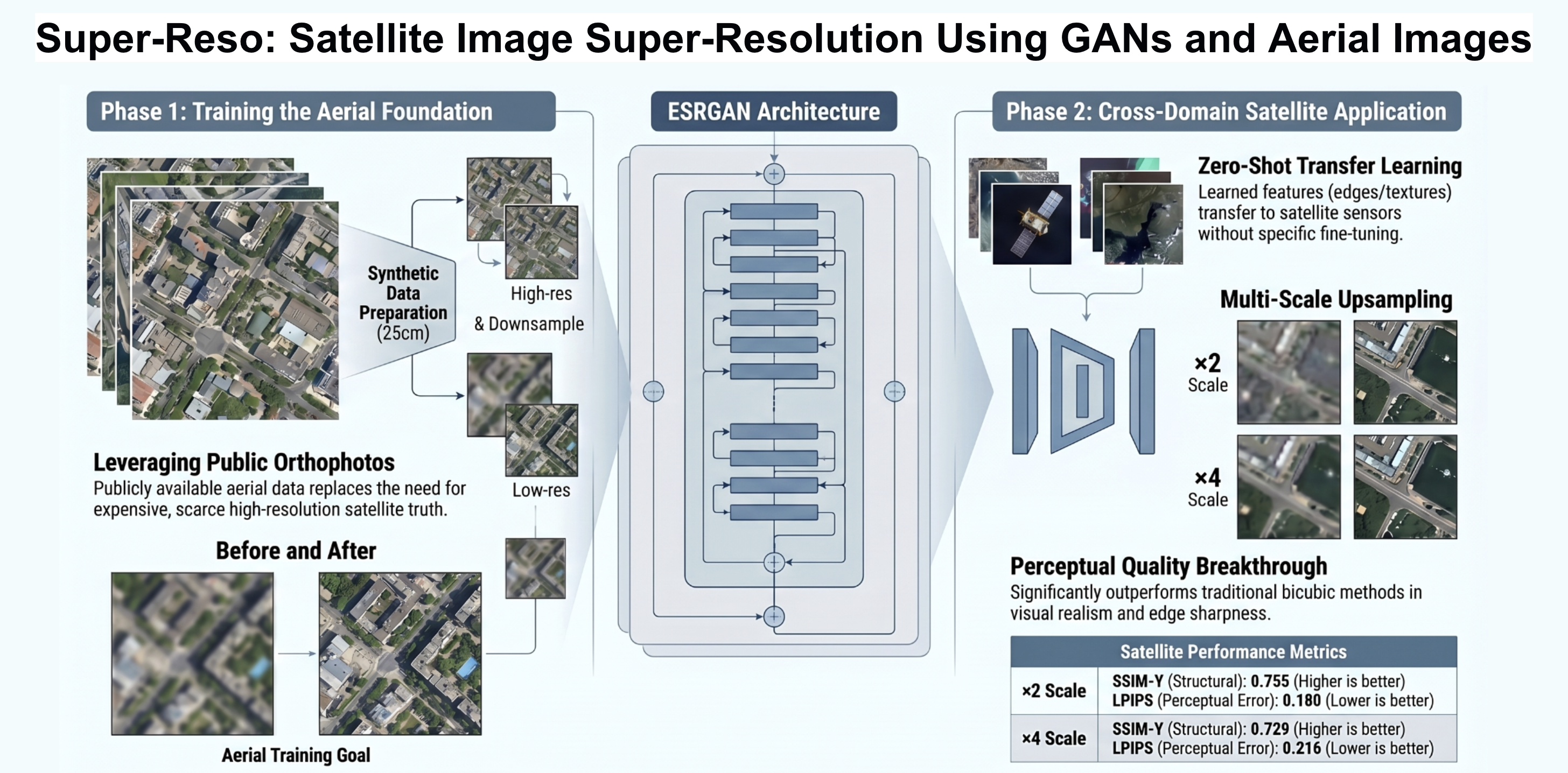
Satellite imagery super-resolution using GANs and aerial images
Keywords:
Adversarial Generative Networks, Satellite Imagery, Aerial Imagery, Deep Learning, Super-ResolutionAbstract
Satellite imagery often suffers from limited spatial resolution and, in many cases, high acquisition costs. These factors restrict their use in applications such as urban monitoring, land management, and wildlife studies. This work proposes an AI-based super-resolution approach that leverages highresolution aerial imagery to train a Generative Adversarial Network. Specifically, the ESRGAN (Enhanced Super-Resolution Generative Adversarial Network) architecture is adapted and trained using aerial orthophotos, enabling the transfer of learned spatial representations to low-resolution satellite images. The trained model is evaluated on satellite image patches at ×2 and ×4 super-resolution scales. Performance is assessed using structural, perceptual, and chromatic metrics, including SSIMY, MS-SSIM, LPIPS and CIEDE2000. The results show clear improvements, with increased sharpness, enhanced edge definition, and consistent reconstruction of urban structures and terrain features. From a quantitative perspective, the ×2 scale achieves the best overall metric values, while the ×4 scale maintains stable and meaningful performance despite the higher reconstruction difficulty. These findings demonstrate the feasibility of transferring super-resolution capabilities from aerial images to satellite imagery, even in the presence of spectral and geometric differences between acquisition domains. Overall, this study provides a solid foundation for the development of low-cost, AI-driven satellite image super-resolution models and outlines future research directions focused on dataset expansion, domain adaptation strategies, and sensor-specific architectural improvements.
Downloads
References
J. Shan, Q. Weng, M. Ehlers, D. A. Quattrochi, G. Zhou, U. Stilla, and S. Anderson, Urban Remote Sensing. CRC Press, 2018, doi: https://doi.org/10.1201/9781315166612.
S. Basheer, X. Wang, A. A. Farooque, R. A. Nawaz, K. Liu, T. Adekanmbi, and S. Liu, “Comparison of land use land cover classifiers using different satellite imagery and machine learning techniques,” Remote Sensing, vol. 14, no. 19, p. 4978, 2022, doi: https://doi.org/10.3390/rs14194978.
M. A. Trujillo-Jiménez, A. L. Liberoff, N. Pessacg, C. Pacheco, L. Díaz, and S. Flaherty, “Satred: New classification land use/land cover model based on multi-spectral satellite images and neural networks applied to a semiarid valley of patagonia,” Remote Sensing Applications: Society and Environment, vol. 26, p. 100703, 2022, doi: https://doi.org/10.1016/j.rsase.2022.100703.
Y. Kang, E. Jang, J. Im, and C. Kwon, “A deep learning model using geostationary satellite data for forest fire detection with reduced detection latency,” GIScience & Remote Sensing, vol. 59, no. 1, pp. 2019–2035, 2022, doi: https://doi.org/10.1080/15481603.2022.2143872.
S. Wang, K. Guan, C. Zhang, Q. Zhou, S. Wang, X. Wu, and Z. Ma, “Cross-scale sensing of field-level crop residue cover: Integrating field photos, airborne hyperspectral imaging, and satellite data,” Remote Sensing of Environment, vol. 285, p. 113366, 2023, doi: https://doi.org/10.1016/j.rse.2022.113366.
L. Salgueiro, J. Marcello, and V. Vilaplana, “Single-image superresolution of sentinel-2 low resolution bands with residual dense convolutional neural networks,” Remote Sensing, vol. 13, no. 24, p. 5007, 2021, doi: https://doi.org/10.3390/rs13245007.
W. Yang, X. Zhang, Y. Tian, W. Wang, J. H. Xue, and Q. Liao, “Deep learning for single image super-resolution: A brief review,” IEEE Transactions on Multimedia, vol. 21, no. 12, pp. 3106–3121, 2019, doi: https://doi.org/10.1109/TMM.2019.2919431.
K. Karwowska and D. Wierzbicki, “Using super-resolution algorithms for small satellite imagery: A systematic review,” IEEE Journal of Selected Topics in Applied Earth Observations and Remote Sensing, vol. 15, pp. 3292–3312, 2022, doi: https://doi.org/10.1109/JSTARS.2022.3167646.
G. Vivone, L. J. Deng, S. Deng, D. Hong, M. Jiang, C. Li, and A. Plaza, “Deep learning in remote sensing image fusion: Methods, protocols, data, and future perspectives,” IEEE Geoscience and Remote Sensing Magazine, vol. 13, no. 1, pp. 269–310, 2025, doi: https://doi.org/10.1109/MGRS.2024.3495516.
C. Lanaras, J. Bioucas-Dias, S. Galliani, E. Baltsavias, and K. Schindler, “Super-resolution of sentinel-2 images: Learning a globally applicable deep neural network,” ISPRS Journal of Photogrammetry and Remote Sensing, vol. 146, pp. 305–319, 2018, doi: https://doi.org/10.1016/j.isprsjprs.2018.09.018.
C. Dong, C. C. Loy, and X. Tang, “Accelerating the super-resolution convolutional neural network,” in European Conference on Computer Vision (ECCV). Springer, 2016, pp. 391–407, doi: https://doi.org/10.1007/978-3-319-46475-6 25.
B. Lim, S. Son, H. Kim, S. Nah, and K. M. Lee, “Enhanced deep residual networks for single image super-resolution,” in Proceedings of the IEEE Conference on Computer Vision and Pattern Recognition Workshops, 2017, pp. 136–144, doi: https://doi.org/10.48550/arXiv.1707.02921.
Y. Zhang, K. Li, K. Li, L. Wang, B. Zhong, and Y. Fu, “Image superresolution using very deep residual channel attention networks,” in Proceedings of the European Conference on Computer Vision (ECCV), 2018, pp. 286–301, doi: https://doi.org/10.48550/arXiv.1807.02758.
J. Liang, H. Zeng, and L. Zhang, “Efficient and degradation-adaptive network for real-world image super-resolution,” in European Conference on Computer Vision (ECCV). Springer, 2022, pp. 574–591, doi: https://doi.org/10.1007/978-3-031-19797-0_33.
F. Pineda, V. Ayma, and C. Beltran, “A generative adversarial network approach for super-resolution of sentinel-2 satellite images,” The International Archives of the Photogrammetry, Remote Sensing and Spatial Information Sciences, vol. XLIII-B1-2020, pp. 9–14, 2020, doi: https://doi.org/10.5194/isprs-archives-XLIII-B1-2020-9-2020.
C. Ledig, L. Theis, F. Husz´ar, J. Caballero, A. Cunningham, A. Acosta, and W. Shi, “Photo-realistic single image super-resolution using a generative adversarial network,” in Proceedings of the IEEE Conference on Computer Vision and Pattern Recognition (CVPR), 2017, p. 105, doi: https://doi.org/10.48550/arXiv.1609.04802.
H. Chen, X. He, L. Qing, Y. Wu, C. Ren, R. E. Sheriff, and C. Zhu, “Real-world single image super-resolution: A brief review,” Information Fusion, vol. 79, pp. 124–145, 2022, doi: https://doi.org/10.1016/j.inffus.2021.09.005.
X. Wang, K. Yu, S. Wu, J. Gu, Y. Liu, C. Dong, Y. Qiao, and C. Change Loy, “Esrgan: Enhanced super-resolution generative adversarial networks,” in Proceedings of the European conference on computer vision (ECCV) workshops, 2018, pp. 0–0, doi: https://doi.org/10.48550/arXiv.1809.00219.
X. Wang, L. Xie, C. Dong, and Y. Shan, “Real-esrgan: Training realworld blind super-resolution with pure synthetic data,” in Proceedings of the IEEE/CVF International Conference on Computer Vision (ICCV), 2021, pp. 1905–1914, doi: https://doi.org/10.48550/arXiv.2107.10833.
A. F. Habib, E.-M. Kim, and C.-J. Kim, “New methodologies for true orthophoto generation,” Photogrammetric Engineering & Remote Sensing, vol. 73, no. 1, pp. 25–36, 2007, doi: https://doi.org/10.14358/PERS.73.1.25.
Y. Hu, D. Stanley, and Y. Xin, “True ortho generation of urban area using high resolution aerial photos,” ISPRS Annals of the Photogrammetry, Remote Sensing and Spatial Information Sciences, vol. 3, pp. 3–10, 2016, doi: https://doi.org/10.5194/isprs-annals-III-4-3-2016.
C. Lanaras, J. Bioucas-Dias, S. Galliani, E. Baltsavias, and K. Schindler, “Super-resolution of sentinel-2 images: Learning a globally applicable deep neural network,” ISPRS Journal of Photogrammetry and Remote Sensing, vol. 146, pp. 305–319, 2018, doi: https://doi.org/10.1016/j.isprsjprs.2018.09.018.
L. Garcia Diaz, “Pueblos abandonados de cataluña. análisis espacial de su dinámica territorial y de los cambios en sus edificaciones,” Bellaterra: Universitat Autònoma de Barcelona, 2023. [Online]. Available: https://ddd.uab.cat/record/283023
Institut Cartogr`afic i Geol`ogic de Catalunya (ICGC), “Ortofoto 25 cm v7r0 color,” Infraestructura de Dades Espacials de Catalunya (IDE), n.d., disponible en línea. [Online]. Available: https://ddd.uab.cat/record/283023
M. Arabboev, S. Begmatov, M. Rikhsivoev, K. Nosirov, and S. Saydiakbarov, “A comprehensive review of image super-resolution metrics: classical and ai-based approaches,” Acta IMEKO, vol. 13, no. 1, pp. 1–8, 2024, doi: https://doi.org/10.21014/actaimeko.v13i1.1679.
M. Hassan and C. Bhagvati, “Structural similarity measure for color images,” International Journal of Computer Applications, vol. 43, no. 14, pp. 7–12, 2012, doi: https://doi.org/10.5120/6169-8590.
Z. Wang, E. P. Simoncelli, and A. C. Bovik, “Multiscale structural similarity for image quality assessment,” in The thrity-seventh asilomar conference on signals, systems & computers, 2003, vol. 2. Ieee, 2003, pp. 1398–1402, doi: https://doi.org/10.1109/ACSSC.2003.1292216.
H. Park and S. Park, “Improving monocular depth estimation with learned perceptual image patch similarity-based image reconstruction and left–right difference image constraints,” Electronics, vol. 12, no. 17, p. 3730, 2023, doi: https://doi.org/10.3390/electronics12173730.
G. Sharma, W. Wu, and E. N. Dalal, “The ciede2000 color-difference formula: Implementation notes, supplementary test data, and mathematical observations,” Color Research & Application: Endorsed by Inter-Society Color Council, The Colour Group (Great Britain), Canadian Society for Color, Color Science Association of Japan, Dutch Society for the Study of Color, The Swedish Colour Centre Foundation, Colour Society of Australia, Centre Franc¸ais de la Couleur, vol. 30, no. 1, pp. 21–30, 2005, doi: https://doi.org/10.1002/col.20070.
P. Nandal, S. Pahal, A. Khanna, and P. R. Pinheiro, “Super-resolution of medical images using real esrgan,” IEEE Access, 2024, doi: https://doi.org/10.1109/ACCESS.2024.3497002.
Z. Zhu, Y. Lei, Y. Qin, C. Zhu, and Y. Zhu, “Ire: Improved image super-resolution based on real-esrgan,” IEEE Access, vol. 11, pp. 45 334–45 348, 2023, doi: https://doi.org/10.1109/ACCESS.2023.3256086.
L. M. Hopkins, W.-K. Wong, H. Kerner, F. Li, and R. A. Hutchinson, “Data augmentation approaches for satellite imagery,” in Proceedings of the AAAI Conference on Artificial Intelligence, vol. 39, no. 27, 2025, pp. 28 097–28 105, doi: https://doi.org/10.1609/aaai.v39i27.35028.
N. Ravi, V. Gabeur, Y.-T. Hu, R. Hu, C. Ryali, T. Ma, H. Khedr, R. R¨adle, C. Rolland, L. Gustafson, E. Mintun, J. Pan, K. V. Alwala, N. Carion, C.-Y. Wu, R. Girshick, P. Doll´ar, and C. Feichtenhofer, “Sam 2: Segment anything in images and videos,” arXiv preprint arXiv:2408.00714, 2024, doi: https://doi.org/10.48550/arXiv.2408.00714.
S. Ren, F. Luzi, S. Lahrichi, K. Kassaw, L. M. Collins, K. Bradbury, and J. M. Malof, “Segment anything, from space?” in Proceedings of the IEEE/CVF Winter Conference on Applications of Computer Vision, 2024, pp. 8355–8365, doi: https://doi.org/10.48550/arXiv.2304.13000.