Tracking the Connection Between Brazilian Agricultural Diversity and Native Vegetation Change by a Machine Learning Approach
Keywords:
Clustering, Self-Organizing Map, Shannon's entropy, spatial panel data, sustainabilityAbstract
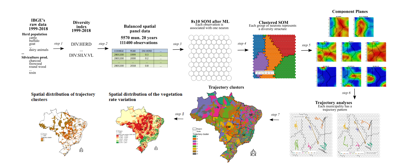
In Brazil, agribusiness has a considerable role in the country's GDP. Because of this, the State needs territorial planning to minimize the impacts on natural resources, especially in the Pantanal and Amazon biomes, where agribusiness has expanded. The lower the agricultural diversification, the lower the pattern of land use homogeneity, generally associated with agribusiness, especially when it occupies large areas with more technological productive units. This paper investigates the relationship between spatial diversification patterns and the dynamics of native vegetation in Brazil. We propose a feature engineering and clustering approach for 5570 Brazilian municipalities between 1999 and 2018. It was based on the unsupervised artificial neural network Self-Organizing Map (SOM) to divide the municipalities into homogeneous groups of agricultural products diversity trends. The results were compared with the change in vegetation area using data from the national land use-mapping project called Mapbiomas. The analysis allowed the identification of three different regimes of modification in native vegetation, particularly related to municipalities in Brazil's Midwest and North regions, indicating substantial changes in the Cerrado and Amazon biomes.
Downloads
References
IBGE, “Sistema IBGE de recuperação automática: tabela 1612 - culturas temporárias.” Available at https://sidra.ibge.gov.br (2022/06/01), 2022.
C. Klink and R. Machado, “Conservation of the Brazilian Cerrado,” Conserv. Biol., vol. 19, pp. 707–713, 2005.
P. Fatch, C. Masangano, T. Hilger, I. Jordan, I. Mambo, J. Francesca, M. Kamoto, A. Kalimbira, and E.-A. Nuppenau, “Holistic agricultural diversity index as a measure of agricultural diversity: A cross-sectional
study of smallholder farmers in Lilongwe district of Malawi,” Agricultural Systems, vol. 187, p. 102991, 2021.
A. Dessie, T. Abate, T. Mekie, and Y. Liyew, “Crop diversification analysis on red pepper dominated smallholder farming system: evidence from Northwest Ethiopia,” Ecological Processes, vol. 8, no. 50, 2019.
R. Sambuichi, E. Galindo, R. Pereira, M. Constantino, and M. Rabetti, “Diversidade da produção nos estabelecimentos da agricultura familiar no Brasil: uma análise econométrica baseada no cadastro da declaração de aptidão ao PRONAF (DAP),” tech. rep., Brasília: Rio de Janeiro, 2016.
L. Pellegrini and L. Tasciotti, “Crop diversification, dietary diversity and agricultural income: empirical evidence from eight developing countries,” Canadian Journal of Development Studies, vol. 35, no. 2, pp. 211–227, 2014.
S. Schneider and A. Cassol, “Diversidade e heterogeneidade da agricultura familiar no Brasil e algumas implicações para políticas públicas,” Cadernos de Ciência & Tecnologia, vol. 31, no. 2, pp. 227–263, 2014.
M. Ogorevc and R. Slabe-Erker, “Assessment of the European Common Agricultural Policy and landscape changes: an example from Slovenia,” Agricultural economics (Praha), vol. 64, no. 11, pp. 489–498, 2018.
C. Tisdell, M. Alauddin, M. Sarker, and M. Kabir, “Agricultural diversity and sustainability: general features and Bangladeshi illustrations,” Sustainability, vol. 11, pp. 6004–6015, 2019.
M. Teixeira and S. Ribeiro, “Agricultura e paisagens sustentáveis: a diversidade produtiva do setor agrícola de Minas Gerais, Brasil,” Sustainability in Debate, vol. 11, no. 2, pp. 29–41, 2020.
C. Sales and R. Rodrigues, “Espaço rural brasileiro: diversificação e peculiaridades,” Revista Espinhaço, vol. 8, no. 1, pp. 54–65, 2019.
E. Shannon, “Mathematical theory of communication,” The Bell System Technical Journal, vol. 28, no. 4, pp. 656–715, 1948.
IBGE, “Tabelas 74, 94, 289, 291, 1612, 1613, 3939 e 3940: sistema IBGE de recuperação automática.” Available at https://sidra.ibge.gov.br(2021/06/15), 2021.
T. Kohonen, Self-Organizing Maps. Berlin: Springer, 2001.
E. Simpson, “Measurement of diversity,” Nature, vol. 163, no. 688, 1949.
A. Hirschmann, “The paternity of an index,” American Economic Review, vol. 54, no. 761, 1964.
A. Skupin and R. Hagelman, “Visualizing demographic trajectories with self-organizing maps,” GeoInformatica, vol. 9, no. 2, pp. 159–179, 2005.
M. Silva, E. Siqueira, and O. Teixeira, “Abordagem conexionista para análise espacial exploratória de dados socioeconômicos de Territórios Rurais,” Revista de Economia e Sociologia Rural, vol. 48, pp. 429–446, 2010.
Qi, H. Liu, X. Liu, and Y. Zhang, “Spatiotemporal evolution analysis of time-series land use change using self-organizing map to examine the zoning and scale effects,” Computers, Environment and Urban Systems, vol. 76, pp. 11–23, 2019.
I.-T. Chen, L.-C. Chang, and F.-J. Chang, “Exploring the spatio-temporal interrelation between groundwater and surface water by using the self-organizing maps,” Journal of Hydrology, vol. 556, pp. 131–142, 2018.
C. Ling and E. Delmelle, “Classifying multidimensional trajectories of neighbourhood change: a self-organizing map and k-means approach,” Annals of GIS, vol. 22, no. 3, pp. 173–186, 2016.
E. W. Augustijn and R. Zurita-Milla, “Self-organizing maps as an approach to exploring spatiotemporal diffusion patterns,” International Journal of Health Geographics, vol. 12, no. 1, 2013.
N. Wang, T. Biggs, and A. Skupin, “Visualizing gridded time series data with self organizing maps: An application to multi-year snow dynamics in the Northern hemisphere,” Computers, Environment and
Urban Systems, vol. 39, pp. 107–120, 2013.
J. Hagenauer and M. Helbich, “Hierarchical self-organizing maps for clustering spatiotemporal data,” International Journal of Geographical Information Science, vol. 27, no. 10, pp. 2026–2042, 2013.
Z. T. Luo, H. Sang, and B. Mallick, “A bayesian contiguous partitioning method for learning clustered latent variables,” Journal of Machine Learning Research, vol. 22, pp. 1–52, 2021.
L. V. Teixeira, R. M. Assunção, and R. H. Loschi, “Bayesian space-time partitioning by sampling and pruning spanning trees,” Journal of Machine Learning Research, vol. 20, pp. 1–35, 2019.
M. A. S. da Silva, L. N. Matos, F. E. de O. Santos, M. H. G. Dompieri, and F. R. de Moura, “Data and R script - Tracking the connection between Brazilian agricultural diversity and native vegetation change by
a Machine Learning approach. Available at https://github.com/marcos-silva-inf/somspatialpaneldata,” 2022.
T. Kohonen, J. Hynninen, J. Kangas, and J. Laaksonen, “SOM PAK: The self-organizing map program package,” tech. rep., Espoo: Finland, 1996.
R. Wehrens and J. Kruisselbrink, “Flexible self-organizing maps in kohonen 3.0,” Journal of Statistical Software, vol. 87, no. 7, pp. 1–18, 2018.
C. Genolini, X. Alacoque, M. Sentenac, and C. Arnaud, “Kml and kml3d: R packages to cluster longitudinal data,” Journal of Statistical Software, vol. 65, no. 4, pp. 1–34, 2015.
M. A. S. d. Silva, L. N. Matos, F. E. O. Santos, F. R. Moura, and M. H. G. Dompieri, “Evaluating a self-organizing map approach to cluster a Brazilian agricultural diversity spatial panel data,” in Proceedings
GEOINFO - Brazilian Symposium on Geoinformatics, pp. 75–86, São José dos Campos: INPE, 2021.
A. Komárek and L. Komárková, “Capabilities of R package mixAK for clustering based on multivariate continuous and discrete longitudinal data,” Journal of Statistical Software, vol. 59, no. 12, pp. 1–38, 2014.
Mapbiomas, “Project Mapbiomas - Collection 6.0 of Brazilian Land Cover Use map series.” Available at http://mapbiomas.org (2022/03/21), 2022. MapBiomas Project - is a multi-institutional initiative to generate annual land cover and use maps using automatic classification processes
applied to satellite images.
L. A. Santos, K. Ferreira, M. Picoli, G. Camara, R. Zurita-Milla, and E.-W. Augustijn, “Identifying spatiotemporal patterns in land use and cover samples from satellite image time series,” Remote Sensing, vol. 13, no. 974, pp. 1–21, 2021.