Change Detection over mining areas using Deep Neural Networks from Planetscope image time series
Keywords:
Change Detection, Deep Learning, Mining areas, PlanetScope, Time SeriesAbstract
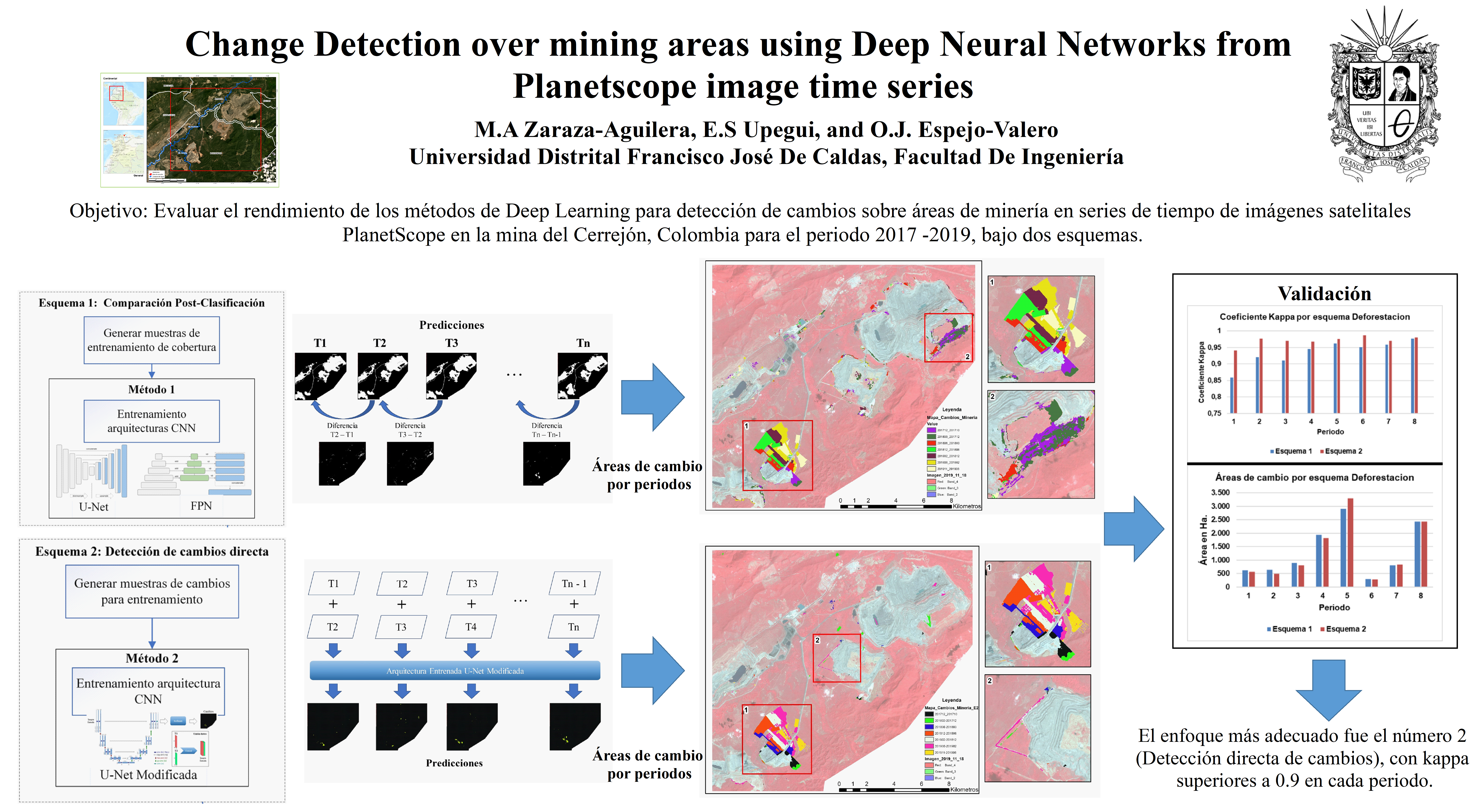
The processes of change detection (CD) in land use and land cover through satellite images acquired in different temporal phases represent a key process to monitor the land, the environment and evaluate disasters. Currently the methodologies used for CD based on pixels do not allow processing a large amount of images massively, so it is not possible to analyze all the available information. Main aim of this research is to evaluate the performance of Deep learning methods for CD, grouped in two approaches, across open mining areas from PlanetScope (PS) image time series of the Cerrejón mine in Colombia. Two approaches for change generation are proposed, one based on post-classification comparison in which two convolutional neural network (CNN) architectures are evaluated: U-Net and Feature Pyramidal Network (FPN) for the classification of mining areas along the time series, for this purpose different models with different hyperparameters were generated and trained to select the most suitable for such process and subsequently perform the difference between the periods of the series; and a second approach based on direct change detection in which a modified U-Net network was evaluated from pairs of images. For this purpose, different models were also trained selecting the most appropriate for the detection of changes for each period of the time series, obtaining a map of changes for each approach, each one the results were validated; the most appropriate approach was number 2 (Direct change detection), with kappa accuracies greater than 0.9 in each period of the time series.
Downloads
References
R. C. Daudt, B. L. Saux, A. Boulch, and Y. Gousseau, “Multitask Learning for Large-scale Semantic Change Detection,” ArXiv181008452 Cs, Aug. 2019, Accessed: Jan. 25, 2021. [Online]. Available: http://arxiv.org/abs/1810.08452
X. Yuan, J. Tian, and P. Reinartz, “Building Change Detection Based on Deep Learning and Belief Function,” in 2019 Joint Urban Remote Sensing Event (JURSE), May 2019, pp. 1–4. doi: 10.1109/JURSE.2019.8808968.
Q. Wang, X. Zhang, G. Chen, F. Dai, Y. Gong, and K. Zhu, “Change detection based on Faster R-CNN for high-resolution remote sensing images,” Remote Sens. Lett., vol. 9, no. 10, pp. 923–932, Oct. 2018, doi: 10.1080/2150704X.2018.1492172.
F. Pacifici, F. D. Frate, C. Solimini, and W. J. Emery, “An Innovative Neural-Net Method to Detect Temporal Changes in High-Resolution Optical Satellite Imagery,” IEEE Trans. Geosci. Remote Sens., vol. 45, no. 9, pp. 2940–2952, Sep. 2007, doi: 10.1109/TGRS.2007.902824.
M. C. Hansen et al., “High-Resolution Global Maps of 21st-Century Forest Cover Change,” Science, vol. 342, no. 6160, pp. 850–853, Nov. 2013, doi: 10.1126/science.1244693.
Y. Li, H. Zhang, X. Xue, Y. Jiang, and Q. Shen, “Deep learning for remote sensing image classification: A survey,” Wiley Interdiscip. Rev. Data Min. Knowl. Discov., p. e1264, May 2018, doi: 10.1002/widm.1264.
L. Ma, Y. Liu, X. Zhang, Y. Ye, G. Yin, and B. A. Johnson, “Deep learning in remote sensing applications: A meta-analysis and review,” ISPRS J. Photogramm. Remote Sens., vol. 152, pp. 166–177, Jun. 2019, doi: 10.1016/j.isprsjprs.2019.04.015.
M. Yang, L. Jiao, F. Liu, B. Hou, and S. Yang, “Transferred Deep Learning-Based Change Detection in Remote Sensing Images,” IEEE Trans. Geosci. Remote Sens., pp. 1–14, 2019, doi: 10.1109/TGRS.2019.2909781.
R. C. Daudt, B. L. Saux, A. Boulch, and Y. Gousseau, “Urban Change Detection for Multispectral Earth Observation Using Convolutional Neural Networks,” in IGARSS 2018 - 2018 IEEE International Geoscience and Remote Sensing Symposium, Jul. 2018, pp. 2115–2118. doi: 10.1109/IGARSS.2018.8518015.
A. M. E. Amin, Q. Liu, and Y. Wang, “Convolutional neural network features based change detection in satellite images,” in First International Workshop on Pattern Recognition, Jul. 2016, vol. 10011, p. 100110W. doi: 10.1117/12.2243798.
M. E. A. Arabi, M. S. Karoui, and K. Djerriri, “Optical Remote Sensing Change Detection Through Deep Siamese Network,” in IGARSS 2018 - 2018 IEEE International Geoscience and Remote Sensing Symposium, Jul. 2018, pp. 5041–5044. doi: 10.1109/IGARSS.2018.8518178.
M. Castelluccio, G. Poggi, C. Sansone, and L. Verdoliva, “Land Use Classification in Remote Sensing Images by Convolutional Neural Networks,” ArXiv150800092 Cs, Aug. 2015, Accessed: Sep. 19, 2019. [Online]. Available: http://arxiv.org/abs/1508.00092
S. H. Khan, X. He, F. Porikli, and M. Bennamoun, “Forest Change Detection in Incomplete Satellite Images With Deep Neural Networks,” IEEE Trans. Geosci. Remote Sens., vol. 55, no. 9, pp. 5407–5423, Sep. 2017, doi: 10.1109/TGRS.2017.2707528.
Y. Li, C. Peng, Y. Chen, L. Jiao, L. Zhou, and R. Shang, “A Deep Learning Method for Change Detection in Synthetic Aperture Radar Images,” IEEE Trans. Geosci. Remote Sens., pp. 1–13, 2019, doi: 10.1109/TGRS.2019.2901945.
G. J. Scott, M. R. England, W. A. Starms, R. A. Marcum, and C. H. Davis, “Training Deep Convolutional Neural Networks for Land–Cover Classification of High-Resolution Imagery,” IEEE Geosci. Remote Sens. Lett., vol. 14, no. 4, pp. 549–553, Apr. 2017, doi: 10.1109/LGRS.2017.2657778.
W. J. D. van Leeuwen, B. J. Orr, S. E. Marsh, and S. M. Herrmann, “Multi-sensor NDVI data continuity: Uncertainties and implications for vegetation monitoring applications,” Remote Sens. Environ., vol. 100, no. 1, pp. 67–81, Jan. 2006, doi: 10.1016/j.rse.2005.10.002.
NUMBER ID: 6556
M. Tsuneki, “Deep learning models in medical image analysis,” J. Oral Biosci., Mar. 2022, doi: 10.1016/j.job.2022.03.003.
F. Behrad and M. Saniee Abadeh, “An overview of deep learning methods for multimodal medical data mining,” Expert Syst. Appl., vol. 200, p. 117006, Aug. 2022, doi: 10.1016/j.eswa.2022.117006.
W. Zhang, X. Gu, L. Tang, Y. Yin, D. Liu, and Y. Zhang, “Application of machine learning, deep learning and optimization algorithms in geoengineering and geoscience: Comprehensive review and future challenge,” Gondwana Res., vol. 109, pp. 1–17, Sep. 2022, doi: 10.1016/j.gr.2022.03.015.
Z. Ma and G. Mei, “Deep learning for geological hazards analysis: Data, models, applications, and opportunities,” Earth-Sci. Rev., vol. 223, p. 103858, Dec. 2021, doi: 10.1016/j.earscirev.2021.103858.
K. Tong and Y. Wu, “Deep learning-based detection from the perspective of small or tiny objects: A survey,” Image Vis. Comput., vol. 123, p. 104471, Jul. 2022, doi: 10.1016/j.imavis.2022.104471.
J. Gallwey, C. Robiati, J. Coggan, D. Vogt, and M. Eyre, “A Sentinel-2 based multispectral convolutional neural network for detecting artisanal small-scale mining in Ghana: Applying deep learning to shallow mining,” Remote Sens. Environ., vol. 248, p. 111970, Oct. 2020, doi: 10.1016/j.rse.2020.111970.
R. Balaniuk, O. Isupova, and S. Reece, “Mining and Tailings Dam Detection in Satellite Imagery Using Deep Learning,” Sensors, vol. 20, no. 23, Art. no. 23, Jan. 2020, doi: 10.3390/s20236936.
M. Hussain, D. Chen, A. Cheng, H. Wei, and D. Stanley, “Change detection from remotely sensed images: From pixel-based to object-based approaches,” ISPRS J. Photogramm. Remote Sens., vol. 80, pp. 91–106, Jun. 2013, doi: 10.1016/j.isprsjprs.2013.03.006.
G. Cao, B. Wang, H.-C. Xavier, D. Yang, and J. Southworth, “A new difference image creation method based on deep neural networks for change detection in remote-sensing images,” Int. J. Remote Sens., vol. 38, no. 23, pp. 7161–7175, Dec. 2017, doi: 10.1080/01431161.2017.1371861.
W. Shi, M. Zhang, R. Zhang, S. Chen, and Z. Zhan, “Change Detection Based on Artificial Intelligence: State-of-the-Art and Challenges,” Remote Sens., vol. 12, no. 10, Art. no. 10, Jan. 2020, doi: 10.3390/rs12101688.
V. Parmar, N. Bhatia, S. Negi, and M. Suri, “Exploration of Optimized Semantic Segmentation Architectures for edge-Deployment on Drones,” ArXiv200702839 Cs, Jul. 2020, Accessed: Jan. 12, 2021. [Online]. Available: http://arxiv.org/abs/2007.02839
A. C. Castro et al., “Evaluación de algoritmos de clasificación en la plataforma Google Earth Engine para la identificación y detección de cambios de construcciones rurales y periurbanas a partir de imágenes de alta resolución,” Rev. Teledetec. Rev. Asoc. Esp. Teledetec., no. 58, pp. 71–88, 2021.
Planet, “PLANET IMAGERY PRODUCT SPECIFICATIONS.” 2021. [Online]. Available: https://assets.planet.com/docs/Planet_Combined_Imagery_Product_Specs_letter_screen.pdf
A. Coca-Castro, M. Rußwurm, L. Reymondin, and M. Mulligan, “Sequential Recurrent Encoders for Land Cover Mapping in The Brazilian Amazon Using Modis Imagery and Auxiliary Datasets,” in IGARSS 2019 - 2019 IEEE International Geoscience and Remote Sensing Symposium, Jul. 2019, pp. 9843–9846. doi: 10.1109/IGARSS.2019.8899114.
M. Rußwurm and M. Körner, “Multi-Temporal Land Cover Classification with Sequential Recurrent Encoders,” ISPRS Int. J. Geo-Inf., vol. 7, no. 4, p. 129, Mar. 2018, doi: 10.3390/ijgi7040129.
O. Ronneberger, P. Fischer, and T. Brox, “U-Net: Convolutional Networks for Biomedical Image Segmentation,” ArXiv150504597 Cs, May 2015, Accessed: Jan. 25, 2021. [Online]. Available: http://arxiv.org/abs/1505.04597
T.-Y. Lin, P. Dollár, R. Girshick, K. He, B. Hariharan, and S. Belongie, “Feature Pyramid Networks for Object Detection,” ArXiv161203144 Cs, Apr. 2017, Accessed: Feb. 02, 2021. [Online]. Available: http://arxiv.org/abs/1612.03144
D. Vallauri, J. Aronson, N. Dudley, and R. Vallejo, “Monitoring and Evaluating Forest Restoration Success,” in Forest Restoration in Landscapes: Beyond Planting Trees, S. Mansourian, D. Vallauri, and N. Dudley, Eds. New York, NY: Springer, 2005, pp. 150–158. doi: 10.1007/0-387-29112-1_21.
W. Zhu et al., “AnatomyNet: Deep Learning for Fast and Fully Automated Whole-volume Segmentation of Head and Neck Anatomy,” Med. Phys., vol. 46, no. 2, pp. 576–589, Feb. 2019, doi: 10.1002/mp.13300.
N. Abraham and N. M. Khan, “A Novel Focal Tversky Loss Function With Improved Attention U-Net for Lesion Segmentation,” in 2019 IEEE 16th International Symposium on Biomedical Imaging (ISBI 2019), Apr. 2019, pp. 683–687. doi: 10.1109/ISBI.2019.8759329.
I. Goodfellow, Y. Bengio, and A. Courville, Deep Learning. The MIT Press, 2016.
R. V. Maretto, L. M. G. Fonseca, N. Jacobs, T. S. Körting, H. N. Bendini, and L. L. Parente, “Spatio-Temporal Deep Learning Approach to Map Deforestation in Amazon Rainforest,” IEEE Geosci. Remote Sens. Lett., pp. 1–5, 2020, doi: 10.1109/LGRS.2020.2986407.
J. E. Ball, D. T. Anderson, and C. S. Chan, “Comprehensive survey of deep learning in remote sensing: theories, tools, and challenges for the community,” J. Appl. Remote Sens., vol. 11, no. 4, p. 042609, Sep. 2017, doi: 10.1117/1.JRS.11.042609.
D. P. Kingma and J. L. Ba, “Adam: A method for stochastic optimization,” 2015.
M. A. Rahman and Y. Wang, “Optimizing Intersection-Over-Union in Deep Neural Networks for Image Segmentation,” in Advances in Visual Computing, Cham, 2016, pp. 234–244. doi: 10.1007/978-3-319-50835-1_22.
J. Brownlee, “A Gentle Introduction to the Challenge of Training Deep Learning Neural Network Models,” Machine Learning Mastery, Feb. 14, 2019. https://machinelearningmastery.com/a-gentle-introduction-to-the-challenge-of-training-deep-learning-neural-network-models/ (accessed Nov. 29, 2020).
P. Olofsson, G. M. Foody, M. Herold, S. V. Stehman, C. E. Woodcock, and M. A. Wulder, “Good practices for estimating area and assessing accuracy of land change,” Remote Sens. Environ., vol. 148, pp. 42–57, May 2014, doi: 10.1016/j.rse.2014.02.015.
T. S. Sharan, S. Tripathi, S. Sharma, and N. Sharma, “Encoder Modified U-Net and Feature Pyramid Network for Multi-class Segmentation of Cardiac Magnetic Resonance Images,” IETE Tech. Rev., vol. 0, no. 0, pp. 1–13, Aug. 2021, doi: 10.1080/02564602.2021.1955760.